
Timber Cruises
Precontact History and Cultural Legacy of Forest Research
Sites
in Southwestern Oregon
Click to enlarge. Annotated 1916 40-acre cruise of SE 1/4 of the NE 1/4 of Sec. 1, Tsp. 31 S., Rng. 6 W., Douglas County, Oregon.
In 1915 Oregon forest property tax laws were enacted that were based on standing timber volumes. Official timber evaluations on private (taxable) forestlands were immediately undertaken in 40-acre increments, using the GLO rectangular survey and Scribner timber volume tables. These evaluations, commonly called timber cruises, were completed by professional contractors on a per-county basis, to establsih primary property values. Cruise records not only provide a good idea as to tree species' sizes, condition, and locations at that time, but also record information of archaeological and historical value regarding homesites, trails, roads, fields, and other cultural artifacts of potential interest.
Scribner board-footage scales were developed during the Civil War to give timber buyers an idea as to how many "board feet" (one square foot by one-inch thickness) each round log contained. These scales remain in use to the present, and are therefor useful for tracking changes in forest conditions over time.
The following table is a summary of the eight 40-acre timber cruises completed in 1916 on the square mile area also containing the Shoestring Research plots, all using the same format as the example shown above.
Table of Scribner board-foot timber volumes for Tsp. 31 S., Rng. 6 W., Sec. 1, as cruised in 1916.
| Sec. 1/4 | 40-Acre | Douglas-fir | Oak | Ave./Acre |
| NE | SE | 200,000 | 0 | 5,000 |
| NW | NE | 150,000 | 30,000 | 4,500 |
| NW | SW | 160,000 | 0 | 4,000 |
| SW | NE | 225,000 | 0 | 5,625 |
| SW | NW | 150,000 | 0 | 3,750 |
| SE | NE | 120,000 | 0 | 3,000 |
| SE | NW | 150,000 | 0 | 3,750 |
| SE | SW | 160,000 | 0 | 4,750 |
| Total | 320 Acres | 1,315,000 | 30,000 | 4,100 |
The 1916 timber cruise data seems to have been hastily compiled, as all of the average tree diameters were 22-inches for each of the 40-acre plots, and they all had either 4 or 5 logs each. This indicates the trees were measured with an "east-side scale" of 16' log lengths, making the trees more than 80 feet tall in most instances. To estimate the number of trees these numbers represent, I fgured a range of values starting with four logs tapering evenly from a 24" butt-cut to a 6" top to get about 400 b.f.; and figured five logs with an even taper to an 8" top to get almost 700 b.f. This means that by 1916 there were only about 6-10 merchantable trees, on average, per acre -- and most likely dating to the 3-9" diameter class of the 1850s and to the same diameter class of the 1870s (see: GLO Diameter Classes, Table 2). That would put the trees at an average spacing of 70-80 feet, or in clusters with tighter spacing, such as represented by the 20-25 foot spacing of the juvenil GLO Bearing Trees. Subsequent measures of bearing trees (should be on file) can tell the story, particularly with pre-clearcut (before 1953) aerial photos as references. It is also possible that scattered older and larger trees had been selectively logged from the area between 1855 and 1915, although no evidence has been found in that regard.
Pages 8 and 9 (highlighted) from standard Scribner Log Scale booklet. "Diameter in inches" is measured at "breast height," or 4 1/2 feet from the ground.
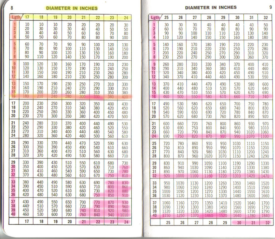
Click to enlarge. Pages 8 and 9 (highlighted) of standard Scribner's log scale booklet, commonly carried and used by timber fallers and log scalers for more than 100 years.
The east boundary of Section 1 was surveyed by Hyde in 1855 (7877), and the north boundary was surveyed the same year, 1855, by Flint (7192), who found only hardwoods (compare with 1953 aerial photos). One 36" fir was on the line near the middle of the eastern mile, but the SE corner used four fir of only 4" to 8" in diameter (probably dating to the 1830s or 1840s) about 25-feet apart to mark corner. The large fir was probably less than 150 years old (likely germinated after 1700), and was only one noted of this size in entire 6-square survey area.
South (7967) and west (7968) boundaries of Section 1 were established nearly 30 years later, by Byars, in 1882. There were still a large number of juvenile Douglas-fir noted at that time, and these may have also grown into log-sized trees by 1916.
![]()