ORWW 2021 Repeat Photography Project
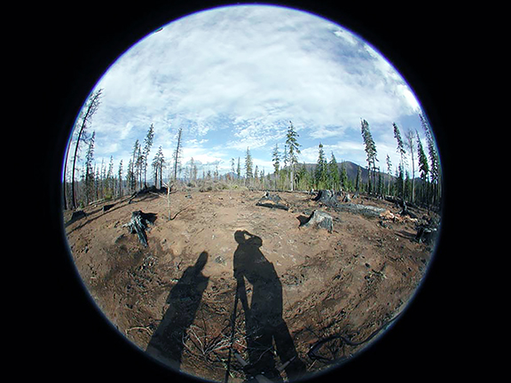
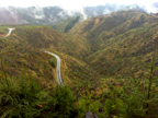
Fisheye Hill, B&B Complex Fire, May 13, 2004. Photo by Bob Zybach
The 2021 Repeat Photography Project has been undertaken for the purpose of consolidating, updating and completing a number of older ORWW websites and bringing them into modern Internet formats for continued current and future uses. Beginning with its first launch on January 15, 1997, the ORWW.org educational website was intended -- and has proven -- to be organic: a growing number of complementary Oregon geography-based educational websites designed to be enlarged, improved, updated, and replicated by Oregon teachers and students over time. All content is focused on the scientific management of our common cultural and natural resources -- and purposefully designed to be freely shared with others who also may be interested in these topics, via Internet communications.
When ORWW.org was created its first project was to teach a network of Benton County and Lincoln County K-12 students how to use email and how to document and share local geographical, cultural, and resource management information with one another -- and with others, over time -- via Internet websites. At that point Internet communications were made possible by school-based 14.4 and 28.8 modems and personal computers with small screens and limited memory. For those reasons, video was nearly impossible and individual photographs loaded very slowly, line-by-line, making it necessary to keep images small and generally 100k or less in size. Initially, select student photos were scanned at 72 dpi resolution from 35 mm prints taken with disposable cameras and then put online; where they have been available ever since and still continue to be used from time to time -- and intended to remain accessible into the foreseeable future.
By 2002, digital cameras, improved Internet speeds, larger screens, and greater computer memories allowed for rapid viewings of more photos at greater resolutions and rudimentary use of video. At the same general time ORWW began working with Oregon K-12 and university students to create short video files and convert digital photo panoramas into QTVR formats. In January, 2008 ORWW created a YouTube Channel, ORWWmedia, and projects that had started as grainy, digital landscape photographs located with difficult and somewhat unreliable GPS coordinates, had evolved into reasonable quality online videos and digital cameras with automated GPS readings of much better quality. Within 10 years digital video, Internet speeds, and computer memories had improved to such a degree that QTVR formats became outdated and then replaced entirely.
The following five websites are comprised of portions of ORWW projects that document specific locations for purposes of both interpretation and replication over time. The common theme is the use of Repeat Photography methods to document conditions at a particular point in time, and then follow the same process at future times in order to compare changes. Potential student projects include updating and enhancing these earlier ORWW websites, replicating past projects and perspectives, and/or interpreting the changes over time. If those efforts can be added to existing ORWW online content, so much the better.
 |
2004 B&B Complex Fire |
The 2004 B&B Complex Fire Project was undertaken as a "post-doc" project by Dr. Bob Zybach under the direction of Bernard Bormann, PNW Research Station.
Nana Lapham, research assistant and human scale, recorded GPS coordinates and marked map locations while Zybach took low resolution panoramic photo sequences on a predetermined grid with a digital camera. The specific purpose of this effort was to document post-fire conditions and then compare with future photo panoramas from the same locations for scientific and management uses. Due to time and expense limitations, complete photo sets were assembled and put online for only a few representative locations. Current projects can be to complete uploading and organizing the remaining original photos, and also to replicate and analyze those sequences now or in the foreseeable future. |
 |
2008 Owl Ridge Trails Project |
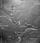
The 2008 Owl Ridge Trails Project was undertaken on a contract basis with the Confederated Tribes of Grand Ronde, under the direction of Dr. David Lewis. The purpose was to locate and document trails used by early historical Molallan and Kalapuyan people in the South Santiam and Blue River headwaters, rather than necessarily consider changing vegetation patterns over time. Dr. Zybach and Lapham, NW Maps Co., collaborated on ground-truthing documentary evidence for the historic trail network, but Repeat Photography interpretation was principally accomplished via historical aerial and Osborne fire lookout photographs, rather than a contemporary grid format. Student projects can expand the annotated aerial photos to a wider geographical area; increase the aerial photo dates and indexes to more recent times than 1981; or replicate the Osborne photos with current photographs or videos from the same locations. |
 |
2010 South Umpqua Headwaters Project |
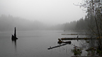
The 2010 South Umpqua Headwaters Project was undertaken on a contract basis with Douglas County, in collaboration with the US Forest Service and Confederated Tribes of Cow Creek Indians. It was conducted under the direction of Joe Laurance, Douglas County Commissioner, and contractor Javier Goirigolzarri. Field research and documentation, data entry, mapping and website construction were by Dr. Zybach and Lapham, with critical GLO research and GIS mapping being primarily accomplished by Terrie Franssen, Douglas County Surveyor's Office. Several dozen QTVR files were assembled for this project, but have become outdated. |
 |
2013 Coquelle Trails Project |
The 2013 Coquelle Trails Project was undertaken on a contract basis with the Confederated Tribes of Coquille Indians in 2011, under the direction of current Chief Don Ivy. A comprehensive grid pattern was established and documentary digital photo panoramas were taken from accessible locations by Dr. Zybach with field assistance by Coquille Tribe employee Jesse Davis. The majority of these photos have yet to be put online, but GIS-mapping of photo locations by Robin Harkins and a representative selection of images demonstrate intended next steps -- hopefully to be undertaken at some point by a local student or students with an interest in this topic. |
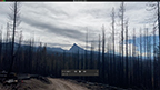 |
2020 Labor Day Fires |
The immediate aftermath of the 2020 western Oregon Labor Day Fires are being documented and uploaded to the ORWWmedia YouTube channel by Dr. Zybach and McKenzie Peters, NW Maps Co. videographer. The perspective is from a vehicle traveling at legal speed along state highways shortly after they have been opened to public traffic. This is the same perspective of wildfire damage, forest regeneration, aesthetics, and wildlife habitat to more than 90% of the residents and visitors who travel through these areas. Video documentation is being done with a common iPhone 11 from the passenger window; quality is sufficient to make detailed video-clips and YouTube indexes capable of being easily replicated by local high school and college students. |

© 2004-2021 Oregon Websites & Watersheds Project, Inc. & NW Maps Co.