Part 2. Historical Accounts, 1826 - 1875
4. The Randolph Trail & Seven Devils: 1853 - 1857
At nearly the same time the Coos Bay Company was colonizing the Empire area to the north, miners discovered a rich lode of “black sand” gold along Whisky Run Creek, on the coast between the Coquille and Coos Rivers. The discovery of gold led to the formation of the boom town of Randolph (Walling 1884: 492; McArthur 1982: 614), adjacent to Whiskey Run Creek, and the development of a “road” to the newly formed port of Empire City (Beckham and Minor 1980: 122; 141; 147; 152-166; 170-171; 187). While gold was being mined at Whiskey Run, members of the Coos Bay Company were discovering rich veins of coal near Empire, North Bend, and Coalbank Slough, a short distance away (Dodge 1898: 133-134).
The principal difference between the two groups is that coal mining was dominated by wealthy businessmen and local landowners, whereas gold mining was almost exclusively American and European single men, footloose and willing to follow any promising rumor; followed closely by Chinese miners – also almost exclusively single men, or men who had left their wives and families back in China – when the rumors had any truth to them.
The tendency of the miners was to brutally confront local Indians, whom were frequently beaten, raped, robbed, and murdered, as there was little consequence to these actions. Miners often banded together to attack and murder Indians they saw as threatening or bothersome for other reasons. Formal law did not punish such crimes when perpetrated by whites on either Indians or Chinese during times of gold rush, and the miners themselves rarely stayed in one place for any length of time so as to avoid any possible revenge or vigilante actions.
“The Randolph Trail” ran directly from the black sand gold mines of Randolph to the newly-formed seaport of Empire City: there were also direct beach and overland trails between Randolph and the Indian villages near the mouth of the Coquille River.
Nasomah Massacre (January 27 - 29, 1854)
On February 5, 1854, Indian Agent F. M. Smith, based in Port Orford, filed a report to the US Department of Interior containing the following information:
| A most horrid massacre, or rather an out-and-out barbarous mass murder, was perpetrated upon a portion of the Nah-so-mah band residing at the mouth of the Coquille River on the morning of January 28 by a party of 40 miners . . . At dawn . . . led by one Abbott, the ferry party and the 20 miners, about 40 in all, formed three detachments, marched upon the Indian ranches and “consummated a most inhuman slaughter,” which the attackers termed a fight. The Indians were aroused from sleep to meet their deaths with but a feeble show of resistance; shot down as they were attempting to escape from their houses. Fifteen men and one squaw were killed, two squaws badly wounded. On the part of the white men, not even the slightest wound was received. The houses of the Indians, with but one exception, were fired and entirely destroyed. Thus was committed a massacre too inhuman to be readily believed (Peterson and Powers 1952: 89-90). |
Miners who actually participated in the attack, including William Packwood, H. R. Scott, J. B. O’Meally, and A. F. Soap, presented the occurrence in a more favorable light (Dodge 1898: 89-94). Victor (1894: 323-328) is the primary source of documentation for Dodge’s account. Hall (1995: 21-22) and Tveskov (2000: 430-432) provide contemporary accounts of the attack, and place it in context to other historical events of that time.
Harper’s Magazine Writer’s Visit (October 1855 – January 1856)
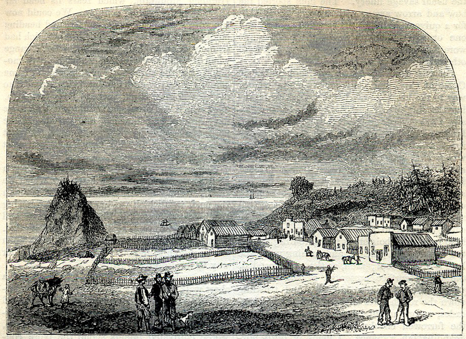
Journalist William V. Wells visited the Port Orford, Coquille River, and Coos Bay area from October 1855 through January 1856 (McArthur 1982: 614; Hall 1995: 41). He subsequently reported on his travels and impressions in the popular Harper’s New Monthly Magazine in a heavily illustrated article titled “Wildlife in Oregon” (Wells 1856; Fig. 1; Table 1).
Wells’ observations were sometimes sensationalistic and even exaggerated, no doubt in order to engage and entertain his intended audience (Hall 1995: 41), but they also contained a significant amount of detail regarding the people and places he visited. Such accounts included his travel along the Oregon Coast, a description of the dying boom town of Randolph, his difficulties in traversing the Seven Devils (“Randolph”) trail, and the inhabitants of Empire City, where he stayed for much of his visit. Wells also describes local Indian communities and their activities at a time when the Rogue River Indian Wars were still taking place, and immediately prior to the removal of most of them to reservations later that year – yet fails to even mention the atrocities then taking place (Wells 1856; Zybach 2012). Despite the limitations and excesses of its written styling, this article has significant historical and cultural value.
Randolph Abandoned (1855 – August 1857)
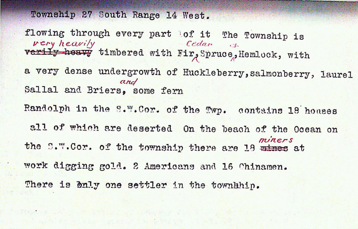
The black sand claims at Randolph were abruptly covered by a winter storm, and the town quickly dissolved thereafter (Wells 1856: 588-608). In August 1857, the GLO surveyors described Randolph in the General Description of Tsp. 27 S., Rng 14 W. as:
| Randolph in the S. W. Cor. Of the Tsp. contains 18 houses all of which are deserted. On the beach of the ocean on the S.W. Cor. Of the township are 18 miners at work digging gold. 2 Americans and 16 Chinamen. There is only one settler in the township. (Murphy and Murphy 1857: 33) |
The bust at Randolph was accelerated by a major strike by “Coarse Gold” Johnson near the headwaters of the South Fork Coquille, and the filing of subsequent claims along the South Fork of the Sixes River (Wooldridge 1971: 271-274). Similarly, additional findings of coal were made at the headwaters of Isthmus Slough and at Eckley. Diller (1903) provides a geological summary of the locations and quality of the area’s gold and coalmines in the Coquille River basin. Beckham (1995)provides a detailed history of the area’s coalmines. The result of all the new and sudden mining activities was the creation of a sudden and all-new transportation network of prospecting trails, pack trails, wagon roads, and even railroads. Most of these appeared to be built on a primary network of existing foot trails and canoe routes, but spurs led in all sorts of new directions – wherever gold or coal was discovered.
![]()